
Replies
25
Beach Fanatic
Sea Bluff. 69 steps down the walkover to the beach. It is also the highest point between Apalachicola and Pensacola.
Edited
Beach Fanatic
Sea Bluff. 69 steps down the walkover to the beach. It is also the highest point between Apalachicola and Pensacola.
I hate to disagree but based on surveying records from the state it is behind the water fountain at Bella Vita. There used to be a survey monument marking the location, it was named the "High" monument. It may still be there. It's famous for also being the highest point in the United states located along the Gulf of Mexico.
SoWal Expert
Blue Mountain Beach is the highest point, not sure as to the exact spot within that area. The county has topo maps if you really want to know for certain.
May I ask why you want to know? If you are buying real estate, the elevation does not necessarily correspond to flood or high risk zones.
May I ask why you want to know? If you are buying real estate, the elevation does not necessarily correspond to flood or high risk zones.
Beach Fanatic
Depends on which floor you are on.
Beach Fanatic
I hate to disagree but based on surveying records from the state it is behind the water fountain at Bella Vita. There used to be a survey monument marking the location, it was named the "High" monument. It may still be there. It's famous for also being the highest point in the United states located along the Gulf of Mexico.
I remember that survey monument but it seems it got eradicated when BV went up.
Didn't they scrape the top of the dune off during construction?

Beach Fanatic
I remember that survey monument but it seems it got eradicated when BV went up.
Didn't they scrape the top of the dune off during construction?
 Actually I saw it post construction.
It was initially surveyed in 1872 for any history buffs out there. Here are the coordinates if anyone is interested to check and see if it still exists.
30 20 22.11064 N
086 12 16.52674 W
Beach Fanatic
I, too, have seen the marked since construction but since I can sit on our walkover and look down on Bella Vita I don't think it is accurate. Admittedly I am biased, however. At any rate, the highest point is on Blue Mountain Beach. I also knew someone would bring up the marker but what I didn't know was that it was there before construction. I never saw it when Bella Vita was a vacant lot.
It was initially surveyed in 1872 for any history buffs out there. Here are the coordinates if anyone is interested to check and see if it still exists.
30 20 22.11064 N
086 12 16.52674 W

Beach Fanatic
I, too, have seen the marked since construction but since I can sit on our walkover and look down on Bella Vita I don't think it is accurate. Admittedly I am biased, however. At any rate, the highest point is on Blue Mountain Beach. I also knew someone would bring up the marker but what I didn't know was that it was there before construction. I never saw it when Bella Vita was a vacant lot.
Isn't BMB also the highest coastal point in Florida? (for that matter, probably coastal America that connects to GOM)

SoWal Insider
I've always heard that we were near "the highest elevation on the Gulf".
And now I'm wondering, does that count Mexico too? Does anybody know?
And now I'm wondering, does that count Mexico too? Does anybody know?
Beach Fanatic
I've always heard that we were near "the highest elevation on the Gulf".
And now I'm wondering, does that count Mexico too? Does anybody know?
The statement should be, "the highest gulf-front point along the Gulf of Mexico in the United States." It often gets shortened but you would be accurate with that statement.
SoWal Insider
I always heard it was Blue Mountain at about 34'-37', but not positive.
Beach Fanatic
Seems to make sense as that spot is almost due south of the highest elevation in Florida. That honor goes to North Walton County at Britton Hill, Lakewood Park, near Paxton -- 345 feet above sea level -- the lowest high in America. Someone else would have to explain or confirm if there is any similarity in geologic era development or major similar ridges, such as the Santa Rosa Ridge, etc.

got any pics?
I thought High Pointe was the highest point 
Beach Fanatic
I don't know if they're the highest point in Florida or the United States of America on the Gulf of Mexico, but I do know that "Highpointe" is NOT in Destin if they are in Walton County. They need to change their promo/advertising to a South Walton address or place. Destin is in Okaloosa County.
SoWal Insider
I'm still curious if Blue Mountain is the highest point on the entire Gulf or just in the United States...
Beach Fanatic
It was initially surveyed in 1872 for any history buffs out there. Here are the coordinates if anyone is interested to check and see if it still exists.
30 20 22.11064 N
086 12 16.52674 W
Do you think we might need a current survey?
In 1872 that part of Walton County was actually in Washington County. If that is first, then what's second. I heard a natural dune around Deer Lake, "K2" hits a pretty high mark.
Beach Lover
There is a small group of mountains between Coatzacoalcos and Tlacotapan, southeast of Veracruz, Mexico I am sure would qualify as the highest point on the Gulf. They are definitely much higher than any point on the U.S. coast.
Beach Fanatic
Do you think we might need a current survey?
Oh, it's been surveyed since along with other nearby locations. Since you like history, did you know that the first comprehensive survey of the US Gulf Coast was started on Dauphin Island around the mid 1850's. While there had been numerous surveys done along areas of the coast, they were either spotty in location or were of questionable quality. Dauphin Island was chosen as the starting point in the Gulf. At the time, the island was almost perfectly straight and they measured from Ft. Gaines to the end (which I believe was seven miles). Then they used surveying techniques to transfer that 7 mile distance along the southeast as a "benchmark." Curiously enough, this work was undertaken by A.D. Bache, who was Benjamin Franklin's grandson.
Some say there was a conspiracy involved in all this though. First, the U.S. Government began this enhanced surveying project in the South. the initial survey had been bogged down in the northeast and had inadequate funding, staffing, etc. Second, the project was started around Ft. Gaines and Ft. Morgan (i.e. the entrance to Mobile Bay). Third, it was started right around the time of the Civil War when the Union needed detailed maps of the Confederacy's shoreline.... :scratch:
Don't know if it's true, but a few Alabamians sure do.
Edited
Beach Fanatic
I thought High Pointe was the highest pointOnly when you are there, RO!


Beach Fanatic
The Highest Point along the entire Gulf Coast is located in one of those seedy motel/condos in Panama City Beach- but only during spring break when the college kids are here and lighting up.
Mary Jane Motel, I believe is the name...........
Mary Jane Motel, I believe is the name...........
Beach Lover
Hi All,
The highest point along 30A's beach front is @ Bella Vita. There is an inbeded marker along side the fountain and about 20' from my condo. It's 64-1/2' elevation above sea level if I remember correctly. I was told it's the highest elevation (beach front) on the entire Gulf coast rim.
Tom
The highest point along 30A's beach front is @ Bella Vita. There is an inbeded marker along side the fountain and about 20' from my condo. It's 64-1/2' elevation above sea level if I remember correctly. I was told it's the highest elevation (beach front) on the entire Gulf coast rim.
Tom

Beach Crab
Where is the highest point al;ong 30a?
Beach Crab
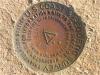
Here's a picture of the marker. I took this pic in 2021. It is set in a stone that is different from all the other Stones around it. It was reported that this Stone was protected during construction and nobody could touch it.
Beach Crab
I hate to disagree but based on surveying records from the state it is behind the water fountain at Bella Vita. There used to be a survey monument marking the location, it was named the "High" monument. It may still be there. It's famous for also being the highest point in the United states located along the Gulf of Mexico.
Beach Crab
Here's a picture of the marker. I took this pic in 2021. It is set in a stone that is different from all the other Stones around it. It was reported that this Stone was protected during construction and nobody could touch it.Actually 09/22/2020
Checking your forum account
Please wait while we verify your forum account.